

Many years ago, Southend was on the tube map. Here's why
The tube map.
If you're like me, you'll have a collection of a whole range of different tube maps stashed in a drawer somewhere. Maybe you'll have one stuck on your wall. If you're especially gawky you'll also have a 'London Rail and Tube Services' map sitting around somewhere and you'll start at it aimlessly for minutes of end, frustrating yourself with the inevitable fact that many stations are all in the wrong geographic locations, as the map is famously non-geographic, placing emphasis on connections rather than physical locations, a highly beneficial advantage, albeit a rather large pet peeve for map addicts such as myself.
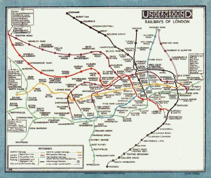
Today I'd like to focus on some of the early tube maps. The one shown above was created in 1926 and was designed to simplify previous maps used at the time. It was very popular and soon found it's way around much of London. The map had it's flaws, however, most notably the issue that even without geographical accuracy, not all of the stations would fit. As a result of this, and to keep the map a destined size, the far flung areas of Watford Junction, Hounslow West and Uxbridge, to name examples, would be confined to boxes around the edge. These stations were not as significant as, say, Liverpool Street, and presumably most of the users of the outlying stations would know their route sufficiently enough to not have to refer to a map.
The outlying boxes included areas both in London and outside London. Watford Junction is in Hertfordshire; Hounslow is in London. Southend, however is notable due to the sheer distance it is from the capital. Southend is far from London. Today, it's eight major stations off the edge of the oyster card system which ends more humbly at Upminster and, on the loop, Grays. Southend is much further than, Hounslow West, or Rickmansworth.
So it brings up the question: even in 1926, why is it on the map?
The simple answer is this: Back in the times before urbanisation, and the existence of Greater London, and far before the existence of TfL, tube lines were run by individual operators that all competed for passengers. London had the Metropolitan Railway, the District Railway, the London Electric Railway...the list goes on. The system in London was much like rail franchising across Britain is today - confusing, competition-driven and monetaily inefficient. (New article coming soon about rail franchising and why it should end). These rail companies weren't interested in boundaries. Greater London was only created in 1965; before that was the important historical county of London and the lesser-valued areas of Middlesex, Hertfordshire, Kent and Essex, many regions being amalgamated into London in 1965. The railway companies weren't constrained geographically, and so were interested in spreading as far as possible.
Because of this, even today the Metropolitan line goes to Chesham, and the Central line went all the way out to sleepy Ongar for a long time.
The Bow Curve
In 1902, a section of track was built connecting the LTS (London - Tilbury - Southend railway, today known as c2c), to the district railway, which would become today's district line. For the first time, stopping services could be run through the capital, along the district railway's route up to Upminster and potentially beyond. Southend was hastily added to the 'green line' on map in an attempt to make London's rail network look as sputtered-out as possible despite not being on the district railway. Interchanges between the District railway and the LTS were created at East Ham, Barking, Dagenham, Hornchurch and Upminster as well as several other suburban stations listed below.
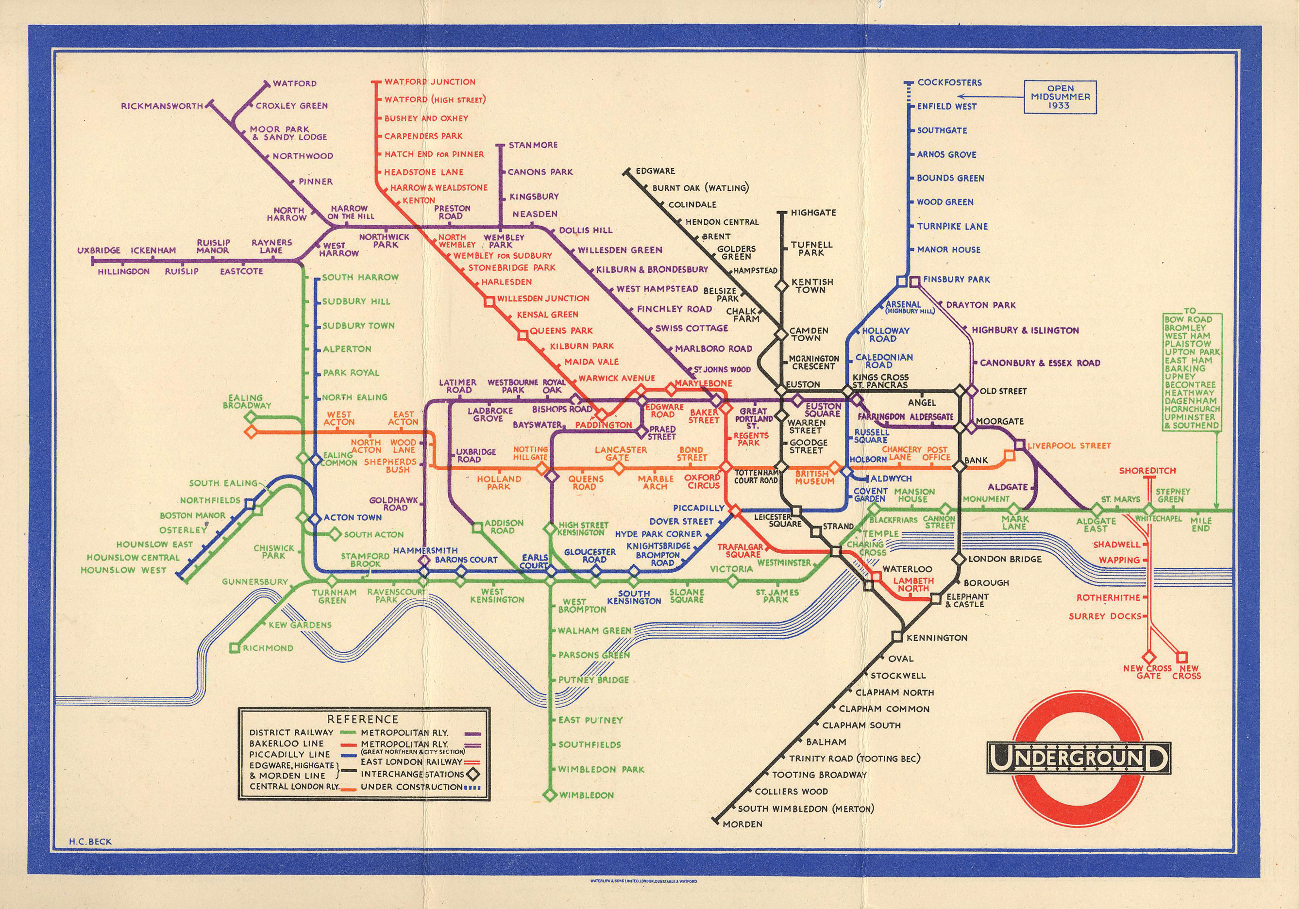 |
| later map designed by Harry Beck in 1932 now included stations between Barking and Upminster, but still listed Southend. |
The original route for the LTS would have run from either Fenchurch Street or Bishopsgate as the two endpoints. A temporary endpoint known as Minories would also be used briefly, which was also the terminus of the London and Blackwall railway company. The LTS would then run to stations at Leman Street, Cannon Street Road, Shadwell, and then Limehouse, before reaching Burdett Road. The Bow Curve would then take trains through Bow Road, Stratford and then the line would rejoin the district line tracks and some point around East Ham and continue on towards Barking.
This was one of the LTS's routes; the other was via a cut-through line built between Bow and Barking to avoid the original Bow Curve and this allowed the LTS to make stops at Bromley-by-Bow, Plaistow, Upton Park, East Ham and then Barking. From Barking onwards, the line would run to Becontree, Dagenham, Hornchurch, Upminster, Ockendon, Grays and then travel onwards to Tilbury, Leigh and Southend.

A very different service to today
Over the succeeding years much changed. Stations at Bishopsgate, Minories, Leman Street, Cannon Street Road, Shadwell and Burdett Road closed, predominantly due to war damage, lack of passenger numbers and issues with leasing between companies. Shadwell remains in use as a DLR and London Overground station today. Trains would now run from Fenchurch Street to Limehouse without stopping. The effectiveness of the new cut-through and the creation of Liverpool Street as a new large terminating point for many East Anglian routes made the Bow Curve permittedly redundant and was reduced to be single track only due to the construction of the DLR. Due to a lack of demand, the Bow Curve is no longer in passenger operation. What's the point of running trains from Stratford to Fenchurch Street along a single track line when Liverpool Street is far more accessible and contains more interchange points? (Article coming soon about my lucky trip along the Bow Curve - forty four minutes between Upminster and Fenchurch Street via Stratford as opposed to the usual twenty two minutes!) In addition to this, the district railway grew with its own new stations being built, causing direct services at Bromley-by-Bow, Plaistow, Upton Park, East Ham, Becontree, Dagenham (East) and Hornchurch to face the axe. Anyone travelling between Barking and Upminster on c2c can keep a look out for the disused and overgrown platforms that exist at these points - but don't try to alight at them!So back to the original question: Southend was on the tube map because 1) trains would run there and 2) rail companies are incredibly egoistic.
 |
| Today's 2020 rail and tube map: you won't see Southend on here! |
If there's one thing we can all agree on though, it's that areas with rail services like Southend don't belong on a tube map. I wouldn't particularly want a Zone 36, and neither would anyone reading this. That said, it would be cool to have a oyster-like system rolled out nationally, and I don't mean those terrible ITSO cards. I wouldn't want to see London Overground at Chalkwell with it's big orange roundels invading provincial suburbs in the assertion of TfL's dominant image. But heck, with London's evergoing expansion, it may be the case in 50 years. Or maybe not. Likely not. Reading is far enough for me as it is.
Of course, if Crossrail was extended to Southend Victoria, I'd be more than happy to see it on the tube map! Article coming about Crossrail extensions soon.


Comments
Post a Comment